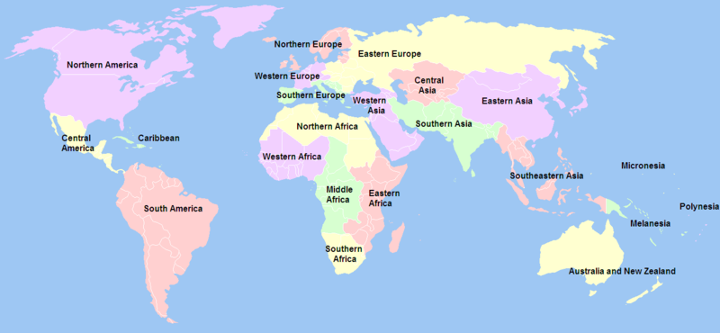
Imachen:United Nations geographical subregions.png

Grandaria d'ista previsualización: 800 × 370 pixels. Atras resolucions: 320 × 148 pixels | 640 × 296 pixels | 1357 × 628 pixels.
Fichero orichinal (1357 × 628 píxels; grandaria d'o fichero: 81 kB; tipo MIME: image/png)
Historial d'o fichero
Punche en una calendata/hora ta veyer o fichero como amaneixeba por ixas envueltas.
| Calendata/Hora | Miniatura | Dimensions | Usuario | Comentario | |
|---|---|---|---|---|---|
| actual | 03:20 21 avi 2012 |  | 1357 × 628 (81 kB) | Spacepotato | Revert to the version of 14 Jan, since in the current version of the UN geographic classification scheme, http://unstats.un.org/unsd/methods/m49/m49regin.htm , South Sudan has been placed in Eastern Africa. |
| 08:36 24 chi 2012 |  | 1357 × 628 (60 kB) | Quintucket | Does it make sense to include South Sudan in East Africa? Yes. Does the United Nations usually do things on the ground that they make sense? No. For now, at least South Sudan is "North Africa" as far as the UN is concerned. | |
| 15:27 14 chi 2012 |  | 1357 × 628 (81 kB) | Дмитрий-5-Аверин | Южный Судан | |
| 02:15 17 feb 2010 |  | 1357 × 628 (81 kB) | Stevanb | I don't see any reason why Kosovo should be listed here because it is not UN recognized country and this is UN geoscheme. | |
| 17:21 15 feb 2010 |  | 1357 × 628 (63 kB) | Dwo | Reverted to version as of 14:34, 18 October 2008 | |
| 18:15 6 avi 2009 |  | 1357 × 628 (63 kB) | Keepscases | Reverted to version as of 03:00, 3 July 2006 | |
| 14:34 18 oct 2008 |  | 1357 × 628 (63 kB) | IJA | + Montenegro as UN member. | |
| 00:19 7 avi 2006 |  | 1357 × 628 (56 kB) | Psychlopaedist | Reverted to earlier revision | |
| 00:18 7 avi 2006 |  | 1357 × 628 (56 kB) | Psychlopaedist | Reverted to earlier revision | |
| 03:00 3 chul 2006 |  | 1357 × 628 (63 kB) | Mexicano~commonswiki | This image was copied from wikipedia:en. The original description was: == Summary == Created by User:Ben Arnold, edited by User:E Pluribus Anthony, from Image:BlankMap-World.png. Information about geographical subregions was obtained from ht |
Uso d'o fichero
A pachina siguient emplega iste fichero:
Uso de fichers globals
Os siguients wikis fan servir iste fichero:
- Uso en ar.wikipedia.org
- Uso en az.wikipedia.org
- Uso en ban.wikipedia.org
- Uso en bbc.wikipedia.org
- Uso en bg.wikipedia.org
- Uso en bn.wikipedia.org
- Uso en ckb.wikipedia.org
- Uso en da.wikipedia.org
- Uso en en.wikipedia.org
- Talk:Melanesia
- Talk:Southern Europe
- Subregion
- User:Big Adamsky
- Wikipedia talk:WikiProject Aviation/Airline destination lists
- User:Nightstallion/sandbox
- Talk:Oceania/Archive 2
- User:Lilliputian/navel ring
- User:Nurg/Continent
- United Nations geoscheme
- Talk:List of European tornadoes and tornado outbreaks
- Talk:Asian Americans/Archive 2
- User:Patrick/Asia
- Talk:2007 FIBA Americas Championship
- Talk:Ethnic groups in Europe/Archive 1
- Wikipedia talk:WikiProject International relations/Archive 2
- List of countries by population (United Nations)
- User:DexDor/Categorization of organisms by geography
- Talk:West Asia/Archive 1
- Uso en es.wikipedia.org
- Uso en et.wikipedia.org
- Uso en fr.wikipedia.org
- Uso en hy.wikipedia.org
- Uso en it.wikipedia.org
Veyer mas información sobre l'uso global d'iste fichero.


