Imachen:Derbyshire UK locator map 2010.svg

Tamaño de esta previsualización PNG del archivo SVG: 494 × 600 pixels. Atras resolucions: 198 × 240 pixels | 395 × 480 pixels | 633 × 768 pixels | 843 × 1024 pixels | 1687 × 2048 pixels | 1108 × 1345 pixels.
Fichero orichinal (fichero SVG, nominalment 1108 × 1345 píxels, grandaria: 302 kB)
Resumen
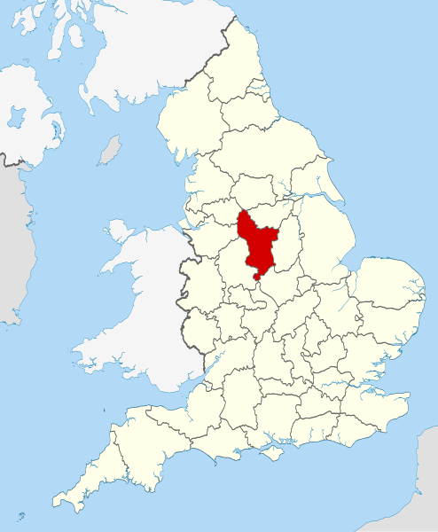
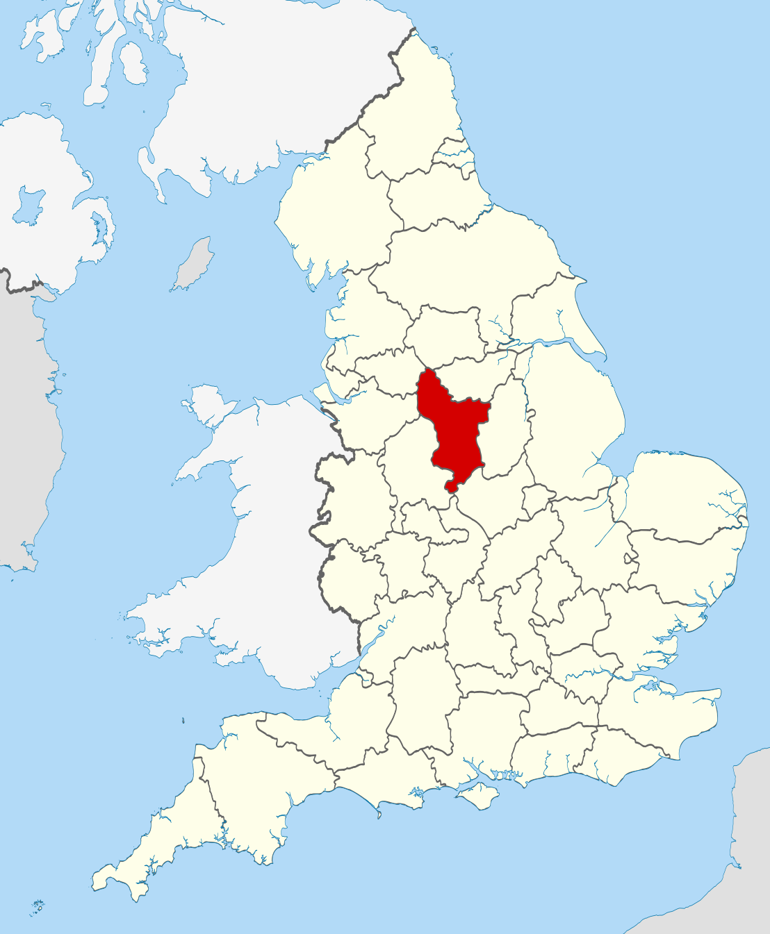
| Descripción | Location of the ceremonial county of Derbyshire within England. |
| Calendata | |
| Fuent |
National Geospatial-Intelligence Agency
|
| Autor | Nilfanion |
Licenciando
Yo, titular d'os dreitos d'autor d'ista obra, la publico en os termins d'as siguients licencias:
Iste fichero se troba baixo a licencia Creative Commons Chenerica d'Atribución/Compartir-Igual 3.0.
- Ye libre:
- de compartir – de copiar, distribuir y transmitir o treballo
- de remezclar – d'adaptar o treballo
- Baixo as siguients condicions:
- atribución d'autoría – Ha d'atribuir l'autoría d'o treballo d'a traza especificada por l'autor u persona que l'haiga licenciau (pero no pas de traza que suchiera que l'autor/os autors refirma(n) u refirma(n) l'uso que faigas d'o treballo).
- compartir igual – En caso d'alterar, transformar u enamplar iste treballo, habrá de distribuir o treballo resultant solament baixo a mesma licencia u beluna equivalent.

|
Se gosa premetir a copia, a destribución y a modificación d'iste decumento baixo d'os termins d'a licencia de decumentación libre GNU, Versión 1.2 u qualsiquier altra versión posteriorment expublicata por a Free Software Foundation; sin de seccions invariaderas (Unvariant Sections), textos de portalada (Front-Cover Texts), ni textos de contraportalada (Back-Cover Texts). S'enclui una copia d'ista licencia en anglés en l'articlo GNU Free Documentation License". |
Vusté puet utilizar a licencia que s'estime mas.

|
This is one of the images forming part of the Valued image set: Locator maps of the Ceremonial counties of England on Wikimedia Commons. The image set has been assessed under the valued image set criteria and is considered the most valued set on Commons within the scope:
Locator maps of the Ceremonial counties of England
You can see its nomination at Commons:Valued image candidates/Locator maps of English ceremonial counties. |
Historial d'o fichero
Punche en una calendata/hora ta veyer o fichero como amaneixeba por ixas envueltas.
| Calendata/Hora | Miniatura | Dimensions | Usuario | Comentario | |
|---|---|---|---|---|---|
| actual | 22:33 23 nov 2010 | | 1108 × 1345 (302 kB) | Nilfanion | == Summary == {{Information |Description=Location of the ceremonial county of Derbyshire within England. |Source=Ordnance Survey [https://www.ordnancesurvey.co.uk/opendatadownload/products.html OpenData]: *County bou |
Uso d'o fichero
A pachina siguient emplega iste fichero:
Uso de fichers globals
Os siguients wikis fan servir iste fichero:
- Uso en af.wikipedia.org
- Uso en ar.wikipedia.org
- Uso en ast.wikipedia.org
- Uso en be-tarask.wikipedia.org
- Uso en be.wikipedia.org
- Uso en bg.wikipedia.org
- Uso en bn.wikipedia.org
- Uso en br.wikipedia.org
- Uso en ca.wikipedia.org
- Uso en ceb.wikipedia.org
- Uso en cs.wikipedia.org
- Uso en dag.wikipedia.org
- Uso en en.wikipedia.org
- Derbyshire
- Thornhill, Derbyshire
- Newhaven, Derbyshire
- Howden Reservoir
- Longdendale Trail
- Leam, Derbyshire
- Tunstead Milton
- Hartshorne, Derbyshire
- Greenhill Lane
- Pilsbury
- River Amber
- Woodhead, Derbyshire
- Lose Hill
- Sparrowpit
- Egginton
- Pikehall
- Win Hill
- Blackwell, Bolsover
- Abbot's Chair
- Abney, Derbyshire
- Ible
- Rattle, Derbyshire
- Beeley
- Birch Vale
- Trent Lock
- Hopton, Derbyshire
- Kedleston
- Template:Derbyshire-geo-stub
- Rushop
- Litton, Derbyshire
- Unstone
- Ault Hucknall
- Butterley
- Abney and Abney Grange
- Aldercar and Langley Mill
- Alderwasley
- Aldwark, Derbyshire
Veyer mas información sobre l'uso global d'iste fichero.