Fichero orichinal(1894 × 1367 píxels; grandaria d'o fichero: 195 kB; tipo MIME: image/png)

Iste fichero ye de Wikimedia Commons y pueden emplegar-lo atros prochectos. Debaixo s'amuestra a descripción d'a suya pachina de descripción.

Esta imagen debería volverse a crear como imágenes vectoriales SVG. Esto proporciona muchas ventajas, véase Commons:Media for cleanup (en inglés) para más información. Si ya hay una versión SVG de esta imagen disponible, por favor súbala a Commons. Tras subirla, reemplace esta plantilla con la plantilla {{vector version available|nuevo nombre de imagen.svg}} en esta imagen.

Resumen

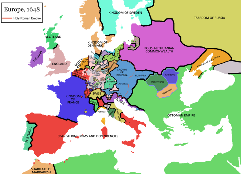
Map of Europe in 1648 (at the end of the Thirty Years War), based on free map of europe Image:BlankMap-Europe.png. Red line marks the border of the Holy Roman Empire. Information from Penguin atlas of modern history. (what year?)

Mapas de la historia de Europa
BCE
aC

Weichselian ice age (c. 113,000–9700) · Neolithic expansion (c. 7000–4500) · Middle Neolithic (c. 4500–4000) · Late Neolithic (c. 4000–3000) · Copper Age – Corded Ware culture (c. 2900–2350) · Copper Age – Bellbeaker culture (c. 2800–1800) · Early Bronze Age – Unetice culture (c. 2300–1600) · Late Bronze Age – Urnfield culture (c. 1300—750) · Migrations (c. 1000–100) · Hallstatt & La Tène cultures (c. 800–100) · Roman Republic (510–40) · 220 · 218 · 200 · 201–100 · 58 · 49 · 39 · 30 BCE–6 CE


CE
dC

14 · 14–37 · 60 · 60 · 69 · 80 · Migrations 100–500 · 117 · 117 · 125 · Migrations 150–774 · Economy 180 · 271 · 293–305 · 337 · 395 · c. 395 · 400 · 400 · 450 · 457–61 · 476 · 480 · Franks 481–814 · Early Slavs 500–700 · 500 · 526 · 526–600 · Christianisation to 600 · c. 550 · 650 · Pontic Steppe 650 · 665 · 800 · Vikings 800–1050 · 814 · 843–70 · 850 · 900 · 912 · 998 · 1000 · 1000 · 1054 · 1092 · First Crusade 1095–99 · 1097 · 1135 · 1142 · 1147–49 · 1190 · 1190 · 1250 · c. 1250 · 1301-1400 · 1301-1400 · 1328 · 1345 · Black Plague 1347–51 · 1360 · 1400 · Trade routes c. 1400 · 1430 · 1470 · 1490 · 1492 · 1500 · 1519 · 1550 · 1560 · Religion 1560 · Religion 1600 · Religion 1618 · 1618–48 · 1648 · 1683 · 1700 · 1701 · 1708 · 1714 · 1721 · 1725–30 · 1739–1740 · 1740 · 1748–66 · 1783–1792 · 1787 · 1787 · 1789 · 1799 · 1812 · 1812 · 1812 · 1812 · 1813 · 1815 · 1815 · 1815 · 1818 · Ottoman Empire 1830–1923 · 1848–49 · 1861 · 1867 · 1871 · 1878 · 1890 · 1905 · 1911 · 1914 · 1914 · 1919 · 1919–29 · 1923 · 1929 · 1930 · 1940 · 1941–42 · 1942–45 · Cold War 1947–91 · 1950 · 1993–2006 · 2006 to date

(this template: · view · discuss )


Licenciando

GNU head Se gosa premetir a copia, a destribución y a modificación d'iste decumento baixo d'os termins d'a licencia de decumentación libre GNU, Versión 1.2 u qualsiquier altra versión posteriorment expublicata por a Free Software Foundation; sin de seccions invariaderas (Unvariant Sections), textos de portalada (Front-Cover Texts), ni textos de contraportalada (Back-Cover Texts). S'enclui una copia d'ista licencia en anglés en l'articlo GNU Free Documentation License".
w:an:Creative Commons
atribución d'autoría compartir igual
Iste fichero se troba baixo a licencia Creative Commons Chenerica d'Atribución/Compartir-Igual 3.0.
Ye libre:
  • de compartir – de copiar, distribuir y transmitir o treballo
  • de remezclar – d'adaptar o treballo
Baixo as siguients condicions:
  • atribución d'autoría – Ha d'atribuir l'autoría d'o treballo d'a traza especificada por l'autor u persona que l'haiga licenciau (pero no pas de traza que suchiera que l'autor/os autors refirma(n) u refirma(n) l'uso que faigas d'o treballo).
  • compartir igual – En caso d'alterar, transformar u enamplar iste treballo, habrá de distribuir o treballo resultant solament baixo a mesma licencia u beluna equivalent.
Ista etiqueta de licencia fue adhibida a iste fichero como parte d'a actualización d'a licencia GFDL.

derivative works

Obras derivadas de ésta:

Leyendas

Añade una explicación corta acerca de lo que representa este archivo

Elementos representados en este archivo

representa a espanyol

tipo de archivo espanyol

image/png

Historial d'o fichero

Punche en una calendata/hora ta veyer o fichero como amaneixeba por ixas envueltas.

(zagueras | primeras) Veyer (10 más recients | ) (10 | 20 | 50 | 100 | 250 | 500)
Calendata/HoraMiniaturaDimensionsUsuarioComentario
actual09:44 14 abr 2021Miniatura d'a versión de 09:44 14 abr 20211894 × 1367 (195 kB)TenanReverted to version as of 16:09, 12 October 2017 (UTC) See discussion
10:47 9 mar 2021Miniatura d'a versión de 10:47 9 mar 20211894 × 1367 (210 kB)TTBCamhReverted to version as of 17:18, 20 September 2018 (UTC). I don't know why Raderich is saying this is an arbitrary change—Catalonia was under the possession of the French king in 1648, following the Catalan Revolt of 1640. This map is correct and the previous one is incorrect.
12:12 25 set 2018Miniatura d'a versión de 12:12 25 set 20181894 × 1367 (195 kB)RaderichReverted to version as of 21:15, 18 September 2018 (UTC) Undone arbitrary changes. Revert to correct map as uploaded by its creator Roke~commonswiki
17:18 20 set 2018Miniatura d'a versión de 17:18 20 set 20181894 × 1367 (210 kB)AmbroiseLThe Catalan counties were French since they proclaimed Louis XIV of France as their king. They wanted to be French in order not to obey the king of Spain anymore. Courland was a quite free vassal state of Poland. The reverted version doesn't show it. The reverted version also doesn't show the Venetian islands in the Adriatic Sea, and the Algerian towns that France occupied. Hence, I re-revert to the more precise version.
21:15 18 set 2018Miniatura d'a versión de 21:15 18 set 20181894 × 1367 (195 kB)RaderichReverted to version as of 16:09, 12 October 2017 (UTC)
10:45 19 chul 2018Miniatura d'a versión de 10:45 19 chul 20181894 × 1367 (210 kB)AmbroiseLReverted to version as of 12:06, 20 January 2017 (UTC) — reverted to the version with fixed names, my mistake
10:37 19 chul 2018Miniatura d'a versión de 10:37 19 chul 20181894 × 1367 (150 kB)AmbroiseLReverted to version as of 10:33, 24 September 2016 (UTC)
16:09 12 oct 2017Miniatura d'a versión de 16:09 12 oct 20171894 × 1367 (195 kB)Reverted to version as of 12:42, 9 September 2016 (UTC) why is Catalonia French? Not shown as such on File:Europe_1648_westphal_1884.jpg
12:06 20 chi 2017Miniatura d'a versión de 12:06 20 chi 20171894 × 1367 (210 kB)FakirbakirNames of Austria, Bohemia and Hungary are fixed.
10:33 24 set 2016Miniatura d'a versión de 10:33 24 set 20161894 × 1367 (150 kB)AmbroiseLAdjunction of polish-lithuanian vassal state of Courland
(zagueras | primeras) Veyer (10 más recients | ) (10 | 20 | 50 | 100 | 250 | 500)

A pachina siguient emplega iste fichero:

Uso de fichers globals

Os siguients wikis fan servir iste fichero:

Veyer mas información sobre l'uso global d'iste fichero.

Metadatos