Imachen:Chagatai Khanate late 13th century locator map.svg

Fichero orichinal (fichero SVG, nominalment 811 × 646 píxels, grandaria: 278 kB)
Resumen
| Descripción |
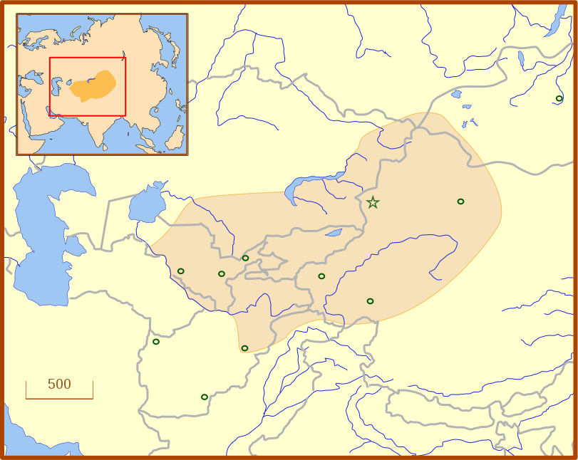
A locator map for the Chagatai Khanate in the late 13th century. The grey lines represent modern international borders. The blue represent rivers. This map uses a Lambert azimuthal equal-area projection. |
| Calendata | |
| Fuent | Treballo de qui la cargó |
| Autor | MapMaster |
| Atras versions | An English language version of the map. See also Image:Golden Horde 1389.svg |
References
- Barnes, Ian; Robert Hudson (1998) The History Atlas of Asia, MacMillan, p. 87.
- Barraclough, Geoffrey (1993) The Times Atlas of World History, 4th Edition, Hammond World Atlas Corporation, ISBN 0723005346, p. 127.
- Facts on File (2002) Historical Maps on File: Ringbound, Facts on File, 2nd Edition, ISBN 081604600X, p. 2.27 "Mongol Invasions of Russian, 12th-13th Centuries".
- Map of the Mongol Empire archive copy at the Wayback Machine, Los Angeles County Museum of Art, accessed 8 July 2008.
These references do not completely agree on the borders of the Khanate. The Facts on File map, for example, shows the borders that stretch to the Caspian Sea, unlike the other three. The eastern border is also slightly different from map to map, which likely reflects the fact that the borders of the eastern half, the nomadic half, were never formally set.
Licenciando
- Ye libre:
- de compartir – de copiar, distribuir y transmitir o treballo
- de remezclar – d'adaptar o treballo
- Baixo as siguients condicions:
- atribución d'autoría – Ha d'atribuir l'autoría d'o treballo d'a traza especificada por l'autor u persona que l'haiga licenciau (pero no pas de traza que suchiera que l'autor/os autors refirma(n) u refirma(n) l'uso que faigas d'o treballo).
Historial d'o fichero
Punche en una calendata/hora ta veyer o fichero como amaneixeba por ixas envueltas.
| Calendata/Hora | Miniatura | Dimensions | Usuario | Comentario | |
|---|---|---|---|---|---|
| actual | 03:07 14 chul 2008 | | 811 × 646 (278 kB) | MapMaster | Adde capital of Almalik |
| 04:19 13 chul 2008 |  | 811 × 646 (277 kB) | MapMaster | {{Information |Description=A locator map for the w:en:Chagatai Khanate in the late 13th century. |Source=self-made |Date=12 July 2008 |Author= MapMaster |Permission= |other_versions= }} |
Uso d'o fichero
A pachina siguient emplega iste fichero:
Uso de fichers globals
Os siguients wikis fan servir iste fichero:
- Uso en azb.wikipedia.org
- Uso en ba.wikipedia.org
- Uso en ca.wikipedia.org
- Uso en eo.wikipedia.org
- Uso en es.wikipedia.org
- Uso en fr.wikipedia.org
- Uso en hy.wikipedia.org
- Uso en ja.wikipedia.org
- Uso en ka.wikipedia.org
- Uso en kk.wikipedia.org
- Uso en ko.wikipedia.org
- Uso en nn.wikipedia.org
- Uso en pt.wikipedia.org
- Uso en ru.wikipedia.org
- Uso en tr.wikipedia.org
- Uso en tt.wikipedia.org
- Uso en uk.wikipedia.org
- Uso en uz.wikipedia.org
- Uso en zh.wikipedia.org