Imachen:Israel location map with stripes.svg

Tamaño de esta previsualización PNG del archivo SVG: 322 × 598 pixels. Atras resolucions: 129 × 240 pixels | 258 × 480 pixels | 413 × 768 pixels | 551 × 1024 pixels | 1102 × 2048 pixels | 614 × 1141 pixels.
Fichero orichinal (fichero SVG, nominalment 614 × 1141 píxels, grandaria: 170 kB)
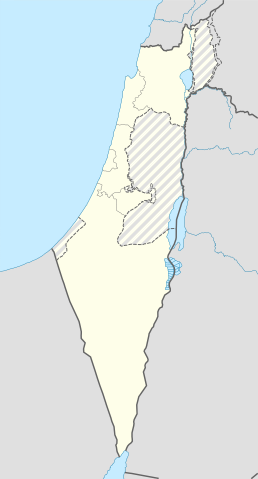
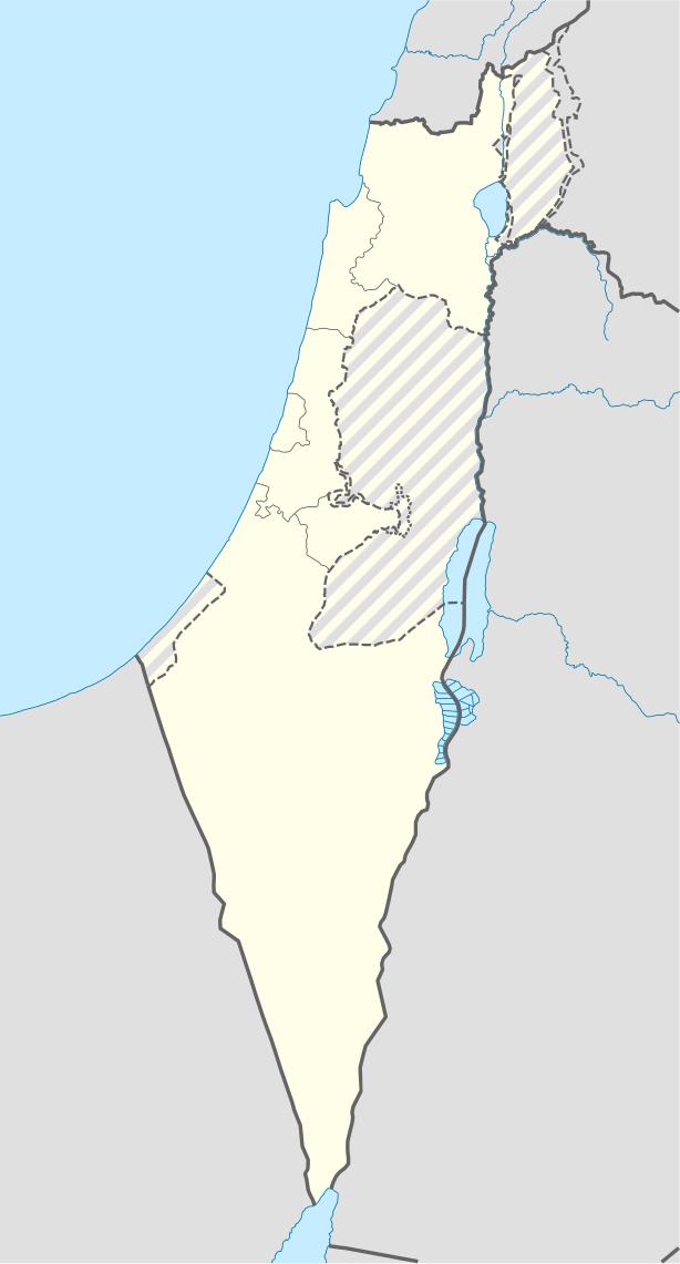
| Descripción | Location map of Israel, with the Israeli-occupied Palestinian territories of the West Bank and the Gaza Strip and the Syrian Golan Heights grey stripes. | ||
| Calendata | |||
| Fuent | Trabajo propio, basado en: Israel location map.svg de NordNordWest | ||
| Autor | Jackmcbarn | ||
| Permiso (Reutilización d'iste fichero) |
Yo, titular d'os dreitos d'autor d'ista obra, la publico en os termins d'as siguients licencias:
Iste fichero se troba baixo a licencia Creative Commons Chenerica d'Atribución/Compartir-Igual 3.0.
Vusté puet utilizar a licencia que s'estime mas. |
||
| SVG desarrollo | El código fuente de esta imagen SVG es válido. Este mapa fue creado con una desconocida SVG herramienta |

Historial d'o fichero
Punche en una calendata/hora ta veyer o fichero como amaneixeba por ixas envueltas.
| Calendata/Hora | Miniatura | Dimensions | Usuario | Comentario | |
|---|---|---|---|---|---|
| actual | 14:43 16 chun 2018 | | 614 × 1141 (170 kB) | Jdx | Reverted to version as of 10:35, 16 June 2018 (UTC) |
| 14:04 16 chun 2018 |  | 504 × 936 (170 kB) | Beebbeebe | Reverted to version as of 00:40, 16 June 2018 (UTC) don't revert without stating a reason | |
| 10:35 16 chun 2018 |  | 614 × 1141 (170 kB) | Denniss | Reverted to version as of 04:28, 21 May 2018 (UTC) | |
| 00:40 16 chun 2018 |  | 504 × 936 (170 kB) | Beebbeebe | Reverted to version as of 19:23, 14 May 2018 (UTC) The current map is simply incorrect. And I don't want to upload a new one, I'll have to edit more than a hundred wiki-articles. | |
| 04:28 21 may 2018 |  | 614 × 1141 (170 kB) | Nableezy | Reverted to version as of 19:08, 18 September 2016 (UTC) actually go back to standard no green or blue lines | |
| 18:23 15 may 2018 |  | 614 × 1141 (174 kB) | Nableezy | Reverted to version as of 03:49, 14 May 2018 (UTC) | |
| 19:23 14 may 2018 |  | 504 × 936 (170 kB) | Eric's son | Reverted to version as of 13:42, 24 March 2018 (UTC) | |
| 03:49 14 may 2018 |  | 614 × 1141 (174 kB) | Nableezy | Reverted to version as of 06:09, 11 March 2018 (UTC) restore golan as occupied territory | |
| 13:42 24 mar 2018 |  | 504 × 936 (170 kB) | Eric's son | Correcting color for border with Jordan | |
| 13:26 24 mar 2018 |  | 504 × 936 (170 kB) | Eric's son | Fixed correct colors with vector |
Uso d'o fichero
As 3 pachinas emplegan iste fichero:
Uso de fichers globals
Os siguients wikis fan servir iste fichero:
- Uso en af.wikipedia.org
- Rehovot
- Nasaret
- Eilat
- Dimona
- Ramla
- Safed
- Tiberias
- Lod
- Ben Gurion Internasionale Lughawe
- Hadera
- Gedera
- Givatayim
- Be'er Sheva
- Rishon LeZion
- Petah Tikva
- Ashdod
- Netanya
- Binyamina-Giv'at Ada
- Bnei Brak
- Holon
- Ramat Gan
- Ashkelon
- Bat Yam
- Beit Shemesh
- Kfar Saba
- Herzliya
- Modi'in-Maccabim-Re'ut
- Ra'anana
- Ramon-lughawe
- Uso en ar.wikipedia.org
- القوات الجوية الإسرائيلية
- قلعة كوكب الهوا
- قالب:Location map Israel Golan
- قالب:Location map Israel ashkelon
- قالب:Location map Israel binyamin
- قالب:Location map Israel center ta
- قالب:Location map Israel haifa
- قالب:Location map Israel jezreel
- قالب:Location map Israel negev mt
- قالب:Location map Israel north haifa
- قالب:Location map Israel north negev
- قالب:Location map Israel northeast
- قالب:Location map Israel northwest
- قالب:Location map Israel northwest negev
- قالب:Location map Israel shomron
- قالب:Location map Israel south wb
- ثقافة كبارية
- مغارة كبارة
- تفجير مطعم شاورما تل أبيب 2006
- وحدة:Location map/data/Emek-beit-shean
- وحدة:Location map/data/Israel
Veyer mas información sobre l'uso global d'iste fichero.